Measure Ground Control Software
0 Reviews
Measure Ground Control Software Specifications
Accounting
Project Scheduling
Project Tracking
Document Management
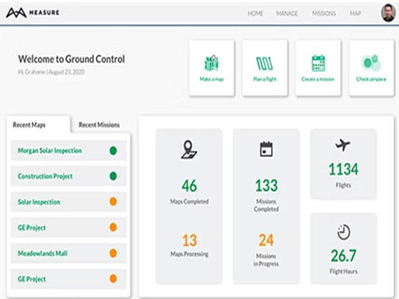
Measure Ground Control is a GIS system that assists enterprises of all sizes in streamlining activities like map generation, flight planning, mission scheduling, equipment management, inspections, and more from a single platform.
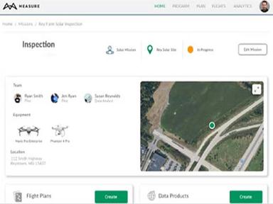
Measure Ground Construction Management lets team members ensure they follow industry rules by keeping and accessing detailed mission information, such as screenshots, playbacks, program activities, incidents, and more. In addition, the data processing feature lets employees upload ground control points (GCPs), make contour maps, design digital surface models, make orthomosaics, and measure linear distances on a single platform.
Measure Ground Control Pricing
Measure Ground Control is offered for free in addition to two other price plans, which are as follows:
The PRO Plan of Measure Ground software costs $69 per month (when paid in full each year) or $99 per month (billed monthly). The ENTERPRISE plan is the advanced tier. If you would like more price information, please contact the vendor directly.
Measure Ground Control Demo
Using the Measure Ground software demo is a great way to try the software before buying it. During the demo, you can learn more about each software feature to see if it meets your needs. In addition, the demo is a real-world setting that will help you decide if the software is worth an investment.
Measure Ground Control Reviews
According to users, Measure Ground Control software is an all-in-one solution that is easy and intuitive. In addition, they offer predefined flight plans at an affordable rate. Please scroll down to read the detailed reviews.
Our Thoughts
Measure Ground Control gives you everything you need to automate your drone operations workflow fully. For example, staff personnel can use the flight control module to organize flights, maintain waypoint patterns, upload flight logs, obtain LAANC authorization, and monitor weather conditions.
Measure Ground Control Software Features
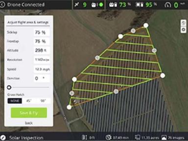
With Measure Ground Control software, you can plan and run flights from a web-based platform in the cloud. For example, you can fly a drone manually with GPS help or automatically with grid and waypoint patterns. You can also send flight plans from the web to the flight app on your phone. The Measure Ground construction management software lets you automatically upload flight logs, pictures, and data. You can also ask for permission from LAANC and stop DJI from sharing data. Last but not least, you can look at the weather and the airspace.
With the Measure Ground Control software, you can use Pix4D, the leader in photogrammetry, to turn images into high-quality data products. For example, with RTK drone data, you can improve image processing accuracy. The software lets you add ground control points (GCPs) to your maps. In addition, you can look at your orthos and other 2D data files on an account-wide map.
With Measure Ground Construction Management software, you can make custom reports for all types of data to meet the needs of your enterprise. In addition, you can use intelligent inspection modes to get information about specific types of assets.
Measure Ground Control Software Reviews
Overall Rating
0
0 Reviews
Rating Distribution
5
(0)
4
(0)
3
(0)
2
(0)
1
(0)
Share your experience
Overall Rating
0
0 Reviews
Rating Distribution
5
0
4
0
3
0
2
0
1
0
Share your experience
Popular Alternatives
Popular Alternatives
Not sure if Measure Ground Control Software is the right fit?
We'll help you shortlist the best tools that fit your budget and business needs. Just fill in the form & we'll get back to you.